
Santa Clara County ZIP Coverage
The working Santa Clara County ZIP code directory below groups the postal places and special-use codes identified in the county research. “Post office” names the primary postal place, not a promise that every code has a separate staffed station. Edge addresses should be checked with USPS before a parcel or resident search begins.
| ZIP Code | Areas Covered | Post Office or Type | Boundary or Search Note |
|---|---|---|---|
| 94022, 94024 | Los Altos and Los Altos Hills | Los Altos | 94024 also appears in Los Altos Hills; the municipal line differs |
| 94035 | Moffett Field and NASA Ames | Moffett Field | Federal or limited-use postal geography |
| 94040, 94041, 94043 | Mountain View | Mountain View | 94041 is central; 94040 is south and west; 94043 is north and east |
| 94085, 94086, 94087, 94089 | Sunnyvale | Sunnyvale | 94089 is north Sunnyvale; city and ZIP edges do not coincide |
| 94301, 94303, 94304, 94306 | Palo Alto | Palo Alto | 94304 includes Stanford-area institutions and foothills; 94303 reaches toward East Palo Alto |
| 94305 | Stanford | Stanford | Campus or institutional ZIP; Stanford is unincorporated Santa Clara County |
| 94309 | Palo Alto | PO boxes | Special postal use; not a street-resident slice |
| 95002 | Alviso and north San José | Alviso | Postal locality within the City of San José |
| 95008, 95009, 95011 | Campbell | Campbell | 95009 and 95011 are PO-box or special mailing ZIPs |
| 95013 | Coyote | Coyote | Rural and sparse postal area |
| 95014, 95015 | Cupertino | Cupertino | 95015 is PO-box or special mailing |
| 95020, 95021 | Gilroy | Gilroy | 95021 is PO-box or special mailing |
| 95023 | Hollister and county-edge service | Hollister | Primarily San Benito County; verify any eastern or southern edge address |
| 95026 | Holy City | Holy City | Small mountain postal locality |
| 95030, 95031, 95032, 95033 | Los Gatos and mountain communities | Los Gatos | 95031 is PO boxes; 95033 crosses the Santa Cruz Mountains and county line |
| 95035, 95036 | Milpitas | Milpitas | 95036 is PO boxes or special mailing |
| 95037, 95038 | Morgan Hill | Morgan Hill | 95038 is PO boxes or special mailing |
| 95042 | New Almaden | New Almaden | Historic and rural locality |
| 95044 | Redwood Estates | Redwood Estates | Santa Cruz Mountains locality |
| 95046 | San Martin | San Martin | Unincorporated community |
| 95050, 95051, 95052, 95053, 95054, 95055, 95056 | Santa Clara | Santa Clara | 95052, 95055, and 95056 are PO-box or special; 95053 is institutional |
| 95070, 95071 | Saratoga | Saratoga | 95071 is PO-box or special mailing |
| 95076 | Watsonville and southern county edge | Watsonville | Mostly Santa Cruz County; verify rural service addresses |
| 95101, 95103, 95106, 95108, 95109 | San José | PO boxes or special mailing | Not useful as residential geography unless USPS confirms a deliverable street address |
| 95110 to 95113 | Central San José | San José | 95113 is compact downtown; airport and city-edge context affects 95110 |
| 95115, 95116 to 95136, 95138 to 95141, 95148 | San José neighborhoods | San José | 95140 covers Mount Hamilton and rural east; 95141 is very small |
| 95150 to 95161, 95164, 95170, 95172, 95173, 95190 to 95196 | San José | PO boxes, organizations, or unique use | Do not treat special codes as geographic resident areas |
This is a research working inventory, not a substitute for a live delivery decision. The accessible official sources did not provide a simple countywide ZIP table with every station name, a confirmed realignment year, or a dated resident count. That gap matters most at county edges, in PO-box groups, and in unique or institutional codes.
Match Santa Clara County ZIPs to Places
A postal code carries a postal place name. A city limit carries municipal jurisdiction. An assessor city label, school district, fire district, neighborhood, and county planning area can all use a different boundary. The ZIP code directory therefore needs a place check before a Santa Clara County request is sent to a records office.
Santa Clara County's Assessor dropdown shows the mismatch in practice. It includes incorporated cities and local names such as Agnew, Alviso, Coyote, Holy City, Moffett Field, Mount Hamilton, Redwood Estates, San Martin, Stanford, Watsonville, and Unincorporated. The research also notes the county's Urban Islands atlas, which maps unincorporated pockets inside or beside incorporated cities.
Geography check. A San José postal line can describe delivery without proving City of San José jurisdiction. Use the APN and GIS parcel location to choose the records custodian.
Use the portal's spelling when a form provides a place choice. The Assessor displays “Moffet Field” with one t, while the federal installation is commonly styled “Moffett Field.” A careful ZIP reference keeps the form label and the prose distinction clear for Santa Clara County searches.
Santa Clara ZIP Codes vs City Limits
ZIP boundaries are delivery constructs, not surveyed lines. A code can serve more than one city, cross a county edge, or point to a campus or PO-box group. The 94304 area includes Stanford-related institutions and foothill settings, while 94303 reaches toward East Palo Alto in San Mateo County. The 95033 area extends through the Santa Cruz Mountains and across a county line.
Special-use ZIPs require a different reading. A PO-box ZIP is built for boxes and special mailing, so it cannot support a street-resident slice without a separate deliverable address. A unique ZIP can serve a single institution. A carrier route is a delivery path within a postal area. ZIP+4 adds delivery detail to a ZIP, but it does not turn postal data into a household roll.
- ZIP code
- A USPS delivery construct used to route mail, not a surveyed city or county boundary.
- ZIP+4
- An added four-digit delivery detail that does not create a public resident list.
- PO-box ZIP
- A special mailing code centered on post-office boxes rather than a street-resident area.
- Unique ZIP
- A code assigned to one institution or special destination, not a broad neighborhood.
- Carrier route
- A delivery path inside a postal area, not a parcel or voter geography.
For an actual Santa Clara County record request, write down the postal place, municipal jurisdiction, and county status as separate fields. This prevents a ZIP label from sending a permit or planning question to the wrong agency.
San Jose ZIP Codes Cross Neighborhood Lines
The San José portion of the Santa Clara County postal directory needs orientation, not a claim of exact neighborhood boundaries. Standard delivery codes generally run through central and north-central San José in the 95110 to 95113 range, east and southeast-central areas in the 95116 to 95122 range, south in 95123 and 95136, west and southwest in 95124 to 95130, north and northeast in 95131 to 95134, and east or rural settings in 95135, 95138, 95139, 95140, and 95148.
Those descriptions are working directions only. A ZIP-wide count must come from a dated statistical product, and a ZCTA is a Census approximation to USPS delivery routes. The research did not locate a per-ZIP voter-registration table or an official ZIP split or realignment year. A neighborhood label should therefore be treated as a clue until USPS and parcel data agree.
For a specific parcel, the ZIP can narrow the first search, but the street address or APN carries the record trail. That is especially important near the airport, foothills, campuses, and city edges.
Santa Clara County Addresses Need County Records
Unincorporated Santa Clara County places include San Martin, Coyote, parts of the mountain areas, New Almaden, Redwood Estates, and rural edges. County Planning and Development, the County Surveyor, and county GIS are the starting points for address and jurisdiction questions there. Incorporated cities manage their own planning and building records.
City limits can also change the answer inside a familiar postal place. County Planning's property profile warns that parcels inside incorporated cities receive limited information, so a city planning department becomes the better custodian for zoning or development facts. San José provides the deepest municipal example, but its permit history is not a countywide substitute.
Before using a Santa Clara County postal guide to choose an office, check the parcel in County GIS map applications, save the APN, and confirm the incorporated or unincorporated status. The address line and the agency line should not be assumed to mean the same thing.
Santa Clara ZIP Discovery to APN Confirmation
Santa Clara County has no public Assessor ZIP filter. The Real Property Search offers simple situs autocomplete, advanced street components and city, and an APN tab. Property Explorer likewise documents address and APN modes. County GIS parcel and address data can support spatial selection or downloaded analysis, but the service is geometry and data, not an occupant list.
- Use the USPS address tool to confirm that the full deliverable address returns the expected ZIP and postal place.
- Open the Assessor search with the situs address, accept the terms, and save the APN rather than treating the ZIP as the parcel key.
- Use County GIS or Property Explorer to check the parcel, jurisdiction, nearby geometry, and relevant planning layers.
- Query a record custodian by the exact address or APN, and label owner, mailing contact, and occupant evidence separately.
| Assessor field or mode | What it does | ZIP limitation |
|---|---|---|
| Simple Property Address | Autocomplete for a situs address after three characters | No ZIP-wide or owner-name search |
| Advanced Street Number, Name, Type, Unit, City | Narrows a property by street components and locality | City is a portal choice, not a ZIP filter |
| Search by APN | Accepts eight digits with or without dashes, such as 12345678 or 123-45-678 | APN is a parcel key, not a postal key |
| Terms checkbox and reCAPTCHA | Required before the search button works | Prevents an unattended bulk ZIP browse |
The FY2025 county parcel service supports JSON, GeoJSON, and PBF queries, permits up to 600,000 records, and limits a selection to 2,000. Parcel data was current to June 2025 in the research capture. Treat the update date and dynamic-service warning as part of any result.
County and city permit portals may accept a full address or APN, while school districts publish attendance-zone finders and public utility districts publish service-area maps. The Registrar of Voters district finder accepts an address for precinct and district geography. None of these channels converts a ZIP into a complete resident directory, so each result still needs an address or parcel check.
[RESEARCH GAP: the manifest has no successful ZIP-capable assessor or GIS search-screen capture; verify the live controls before promising ZIP-wide filtering.]
Santa Clara Directories Before Modern ZIP Codes
Historical city directories were arranged by town, surname, street, and publication year, not by the modern ZIP code directory. The Santa Clara County historical trail uses San José Public Library California Room holdings from the late nineteenth century into the twentieth century, with print and microfilm ranges that should be checked volume by volume. Complete digitized volumes include 1870, 1887, and 1920, with digitized business sections from 1870 through 1918.
A historical address may sit under an older town name, a different city limit, or a street name that later changed. San José's 14th Street became 17th Street in 1913. A current ZIP cannot repair that historical mismatch. Use the directory's coverage key, street index, maps, and the California Room street-name-change list before treating a missing entry as evidence.
Reverse directories from the mid-1960s onward can turn an address into a listed householder, but exact volumes vary and access is mainly through the California Room. A ZIP narrows modern geography; the historical source still needs its own year and street context.
Santa Clara County ZIP Contexts
The 2020 Census counted 1,936,259 people across Santa Clara County's 15 incorporated cities and unincorporated communities. That scale explains why one postal directory cannot stand in for one Santa Clara County record system. North County places such as Palo Alto, Mountain View, Los Altos, Sunnyvale, and Stanford carry university, institutional, and older suburban collections. South County places such as Morgan Hill, San Martin, and Gilroy carry agricultural, rancho, and unincorporated address trails.
The Santa Clara Valley's record eras also differ. Orchard-era parcels may need deeds, agricultural sources, maps, and newspapers. Postwar tract areas are more readily bridged through subdivision maps, permits, directories, and APNs. A ZIP only says how mail is routed now; the record trail follows the source's date and jurisdiction.
Use that local geography to choose a better starting office. A Stanford-area institutional code, a mountain locality, and a central San José delivery code may share a county but not a custodian or a useful search mode.
Verify Santa Clara County ZIPs with USPS
The official USPS ZIP Code Lookup is the final check for a deliverable Santa Clara County address. Enter the full street address and preserve the standardized result, including the returned postal place. USPS validation can settle a boundary or spelling question, but it does not reveal parcels, owners, voters, or occupants.
The USPS lookup screenshot below is linked to the source that supplies the postal verification step.
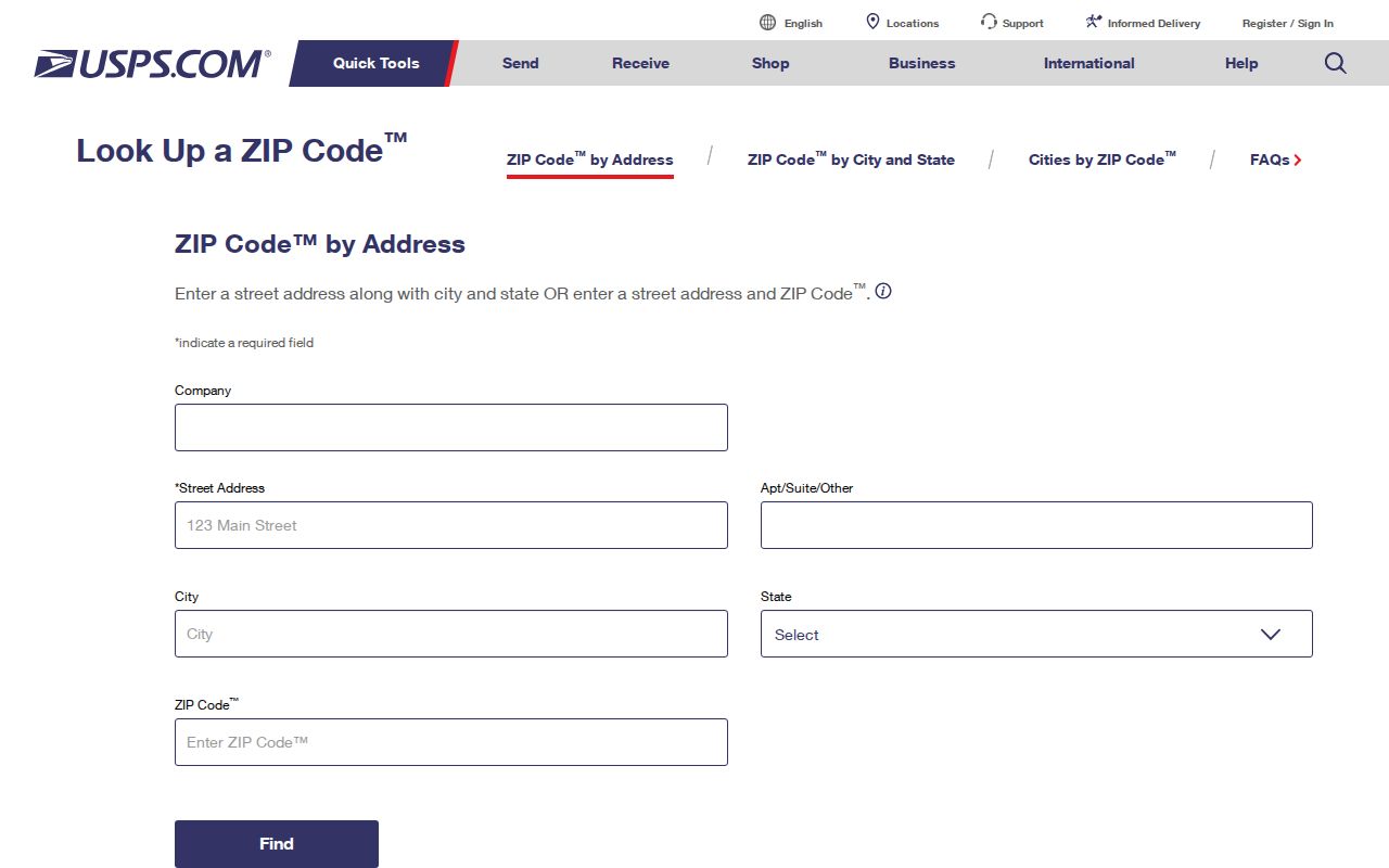
Use the result as a postal key, then switch to the APN or the appropriate city or county record channel for a resident question.
USPS did not publish a simple official countywide table in the inspected lookup interface. The working inventory should be rechecked for edge, PO-box, and unique codes before a final request is sent. A ZIP that cannot be tied to a deliverable street address should not be turned into a resident list.
Santa Clara APN Continuity Across ZIPs
An address or postal code can change while a parcel's legal description remains the stronger bridge. The APN is an assessor identifier, conventionally shown as eight digits in a 123-45-678 pattern. It is not the deed's legal description, and it can be retired when lots split, combine, or are remapped.
When a ZIP, street label, or house number looks different across records, preserve the APN, tract or map reference, lot and block, and recorded legal description. County map books and survey indexes can bridge older citations. A deed records a title transfer; it does not enumerate every person at the site.
The most reliable Santa Clara County postal workflow is layered: USPS for delivery, GIS for place and parcel, Assessor for APN and current property detail, and the responsible custodian for the actual record. That sequence keeps postal geography from becoming an unsupported claim about a resident.